Our Urban Watershed
The Dog River and its creeks and streams drain most of Mobile, Alabama and serve as important places for families to play and fish. The river is greatly affected by the land surrounding the river and our urban watershed that drains into it.
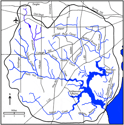
Dog River is approximately 7 miles long with 127 miles of shoreline and located on the northwest side of Mobile Bay. The bay is one of the largest watersheds in the North American continent and tidally influences Dog River, making our ‘river’ an estuary that plays a critical role in the health and success of all aquatic life for the bay, the gulf of Mexico and beyond. Our waters and lives are connected by tides, wind, development, and lifestyle.
Even if you don’t live near the river, you still live in a watershed. All land drains rain & water and flows down based on the topography of the area. A watershed is like a big drain. All the rain that falls within our land areas eventually drains into Dog River. Dog River Watershed is a 95 square mile urban watershed that drains into Dog River, Mobile Bay and eventually the Gulf of Mexico. Chances are if you live in Mobile, Alabama, you live closer to the water than you may realize!
The majority of the Dog River watershed is located within the City of Mobile. The rest is located in Mobile County. Land use change is the largest threat to the health of the River.
Check out the DOG RIVER WATERSHED MANAGEMENT PLAN!!
Dog River Creeks, Bayous and Canals
- Alligator Bayou
- Perch Creek
- Robinson Bayou
- Rabbit Creek
- Rattlesnake Bayou
- Halls Mill Creek
- Milkhouse Creek
- Second Creek
- Spring Creek
- Moore Creek
- Eslava Creek
- Bolton Branch
- Woodcock Branch
- Montlimar Canal
- Michael Blvd. Canal